Currently, meteorologists along the East Coast are keeping an eye on the tropical storms Humberto and Imelda.
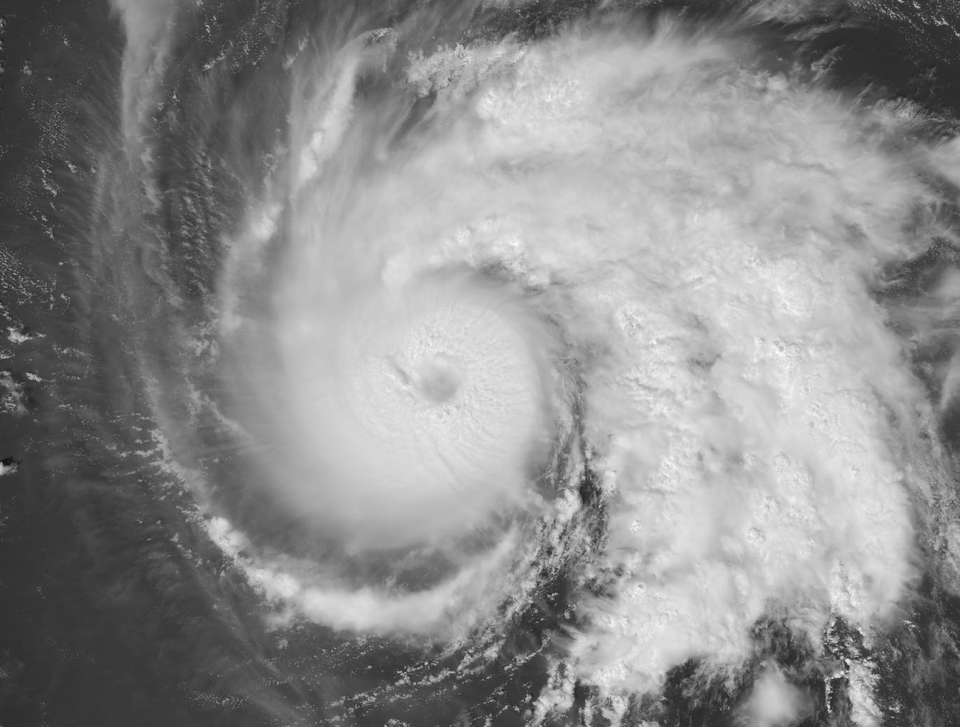
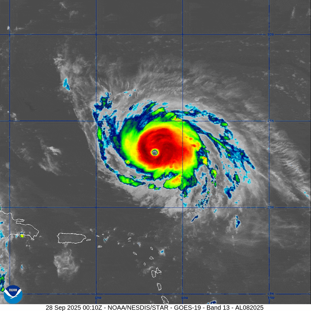
Humberto began forming on Friday, September 26, in the Atlantic Ocean. It began as a tropical depression, but after undergoing rapid intensification, it quickly developed into a Category 5 hurricane within a time of 48 hours.
It’s not said to make serious landfall, but it’s expected to still cause immense flooding of 2-10 inches depending on the area. It also includes intense rip currents and waves that will affect the East Coast starting Monday, September 29.
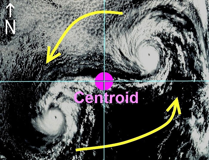
Just behind it, Tropical Depression Imelda began to form a short distance from Humberto on September 27th, in the Caribbean Sea just north of Cuba. Imelda was temporarily named “Tropical Depression Nine,” but due to its proximity to Humberto, the two began a Fujiwhara effect. Imelda has now peaked at 40mph+ winds, developing its current name.
Tropical Depression Imelda carries up to 10 inches of rain for the Carolina coasts, and widespread wind speeds that are yet to be fully predicted. There is a good chance that Humberto will pull Imelda away from the Carolina coasts.
It’s expected to become at least a weak Category 1 by the time it makes landfall, reaching as far as Georgia to Virginia.
It’s most likely going to make landfall by Tuesday, September 30, with most models showing a chance of the storm turning off into Bermuda just like Humberto will. There’s also a chance of the storm moving more slowly, increasing flood risks.
Watch and view places like The Weather Channel, AccuWeather, FOX Weather, and online weather trackers and hurricane pattern updates.
Hurricanes form when rising warm and moist air from the ocean, most commonly in the tropics and close to the equator, creates a low-pressure center, which is then fueled by a continuous flow of evaporation, condensation, and heat release.
Rapid Intensification happens when the right conditions are met for a storm to increase and gain power in as little as 24 hours. It’s also influenced by the amount of thunderstorms and heat within a storm. A storm with a small eye can also cause the storm to move faster, and create a phenomenon called “angular momentum conservation”.
A Fujiwhara effect is a rare phenomenon that happens when two nearby storms begin to orbit each other, causing an interaction between their wind flows. This happens when two tropical cyclones are within 900 miles (1,400km) of each other, or when two extratropical storms are within 1,200 miles (2,000km) of each other.
Also called a “dance”, the storms begin to circle each other, pulling greater strengths, faster wind speeds, more rain, and a wider circumference.
The outcome of a Fujiwhara effect depends on a storm’s size and strength. If the storms are of similar strength, they will typically orbit each other and then move on their separate ways. If one storm is significantly stronger, it can either weaken the other or absorb it completely. In some cases, the interaction can pull the storms onto a new, merged path.
An example of a Fujiwhara effect would be the interaction between hurricane Hilary and tropical storm Irwin in 2017, in the Pacific Ocean. During this, Hilary forced Irwin to change course, orbiting until Hilary absorbed Irwin and merged into one big storm.
Remembering the effects of Hurricane Helene last year, and how sudden and unexpected it was, here are ways that you can prepare and plan for any flooding and severe damage that’s yet to come.
1. Supplies.
Make sure to have plenty of food, bottled water, medical supplies, and at least one generator in case of a power outage. Fire extinguishers are also recommended, especially for those who live in the Burningtown area who can’t contact fire rescue within 30 minutes or less.
Be sure to have an escape route in case of emergency, emergency contact numbers that are nearby, and a full tank of gas.
2. Home Preparation.
Ensure sealing up any cracks and door openings that could cause worsening flooding indoors, and keep any valuable and sentimental items in higher places to avoid damage if flooding occurs. Make sure to bring any outdoor items inside to avoid the chance of loss or damage.
3. Evacuation and Cell Service Loss.
If you live somewhere prone to severe flooding and are considering evacuation, do so. If cell service is lost, like it was during Helene, consider purchasing a phone line or a cheap and working rotary phone that doesn’t rely so much on cellular and WiFi.